

Swanage is one of the best places in Dorset for coastal and countryside walking, with routes ranging from short clifftop walks to longer hikes across the Isle of Purbeck. The South West Coast Path passes through the town, heading north towards Ballard Down, Old Harry Rocks and Studland, and south through Durlston Country Park towards Dancing Ledge and Worth Matravers.
There are also several excellent inland routes linking Swanage with Corfe Castle and the Purbeck Hills. Many of the longer walks can be completed as one-way routes, with the option of returning to Swanage by bus or, from Corfe Castle, on the Swanage Railway.
On this Page
- Swanage to Durlston Country Park Circular Walk
- Swanage to Old Harry Rocks Walk
- Swanage to Old Harry Rocks and Studland Walk
- Swanage to Sandbanks Ferry Walk
- Swanage to Bournemouth Pier Walk
- Swanage to Corfe Castle Walk
- Swanage to Old Harry Rocks and Corfe Castle Walk
- Swanage to Durlston and Dancing Ledge Circular Walk
- Swanage to Worth Matravers Walk
- Swanage to Worth Matravers via the Priests Way Circular Walk
- Swanage to Kingston Walk
Best Swanage Walks
The walks below include approximate distances and walking times, together with route descriptions and return options where appropriate.
Swanage to Durlston Country Park (Circular walk)
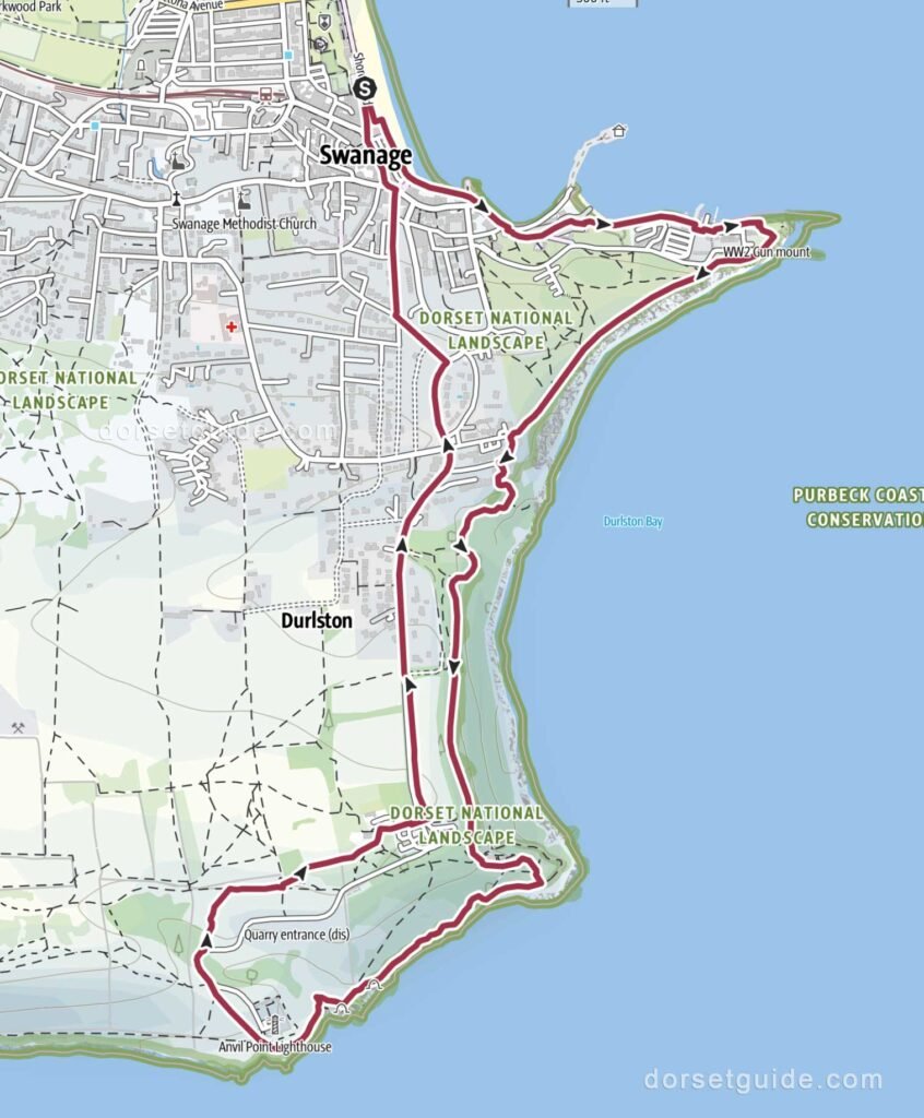
Distance: Approximately 4.1 miles (6.6 km)
Walking time: 2 hours
Route: Swanage – Peveril Point – Durlston Country Park – Durlston Castle – Great Globe – Anvil Point Lighthouse – Visitor Centre – Swanage
GPS Map (external link): https://www.outdooractive.com/
This relatively short circular walk is one of the best introductions to the coast around Swanage. Starting from the seafront, the route follows the coast around Peveril Point before continuing into Durlston Country Park.
The walk passes Durlston Castle and the Great Globe before continuing along the cliffs towards Anvil Point Lighthouse. There are excellent views along the Purbeck coast, while the surrounding grassland and cliffs are particularly good for wildflowers, butterflies and seabirds.
The return route heads inland through Durlston Country Park before descending back into Swanage. Although the walk is only just over four miles, there are several climbs and descents along the way.
Swanage to Old Harry Rocks Walk (one-way)
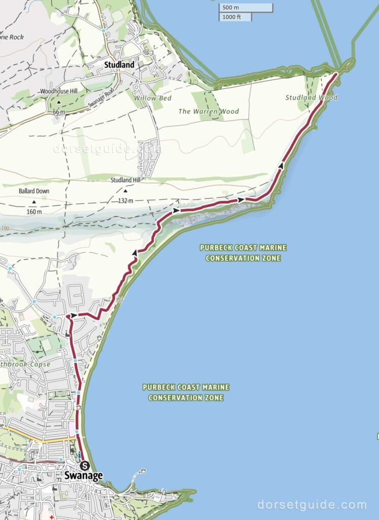
Distance: Approximately 3.3 miles (5.3 km) each way
Walking time: 1 hour 30 minutes
Route: Swanage – Ballard Point – Old Harry Rocks
GPS Map (external link): https://www.outdooractive.com/
Old Harry Rocks is one of the most popular walking destinations from Swanage. From the town, the route follows the seafront and North Beach before climbing onto Ballard Down, where there are extensive views across Swanage Bay and the surrounding Purbeck countryside.
The path continues across the chalk downland before reaching Old Harry Rocks, a group of distinctive chalk stacks and cliffs marking the eastern end of the Jurassic Coast. From the clifftop there are views across Poole Bay towards Bournemouth and the Isle of Wight.
Return Options
You can return to Swanage along the same route or continue towards Studland to turn the walk into a longer one-way route.
Swanage to Old Harry Rocks and Studland Village Walk (one-way)
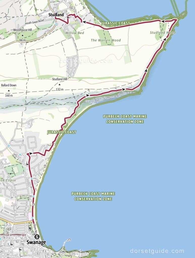
Distance: Approximately 4.7 miles (7.6 km)
Walking time: 2 hours
Route: Swanage – Ballard Point – Old Harry Rocks – Studland Village (Bankes Arms Inn, St. Nicholas’ Church, Village Stores)
GPS Map (external link): https://www.outdooractive.com/
This walk extends the Old Harry Rocks route by continuing along the coast to Studland. After climbing from Swanage onto Ballard Down, the path crosses open chalk grassland before reaching Old Harry Rocks.
From Old Harry Rocks, the South West Coast Path continues around Handfast Point and descends towards Studland. The final section offers attractive views across Studland Bay before reaching the village and nearby beaches.
Return Options
- Return by Purbeck Breezer 50 bus service from Studland village to Swanage
- Walk back same route or a slightly more direct route via Studland Hill
Swanage to Sandbanks Ferry Walk
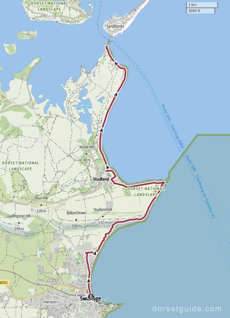
Distance: Approximately 7.5 miles (12.1 km)
Walking time: 3 hours 5 minutes
Route: Swanage – Ballard Point – Old Harry Rocks – Studland Village (Bankes Arms Inn, St. Nicholas’ Church) – Fort Henry – Middle Beach – Knoll Beach – Studland Beach (naturist) – Shell Bay – Sandbanks Ferry
GPS Map (external link): https://www.outdooractive.com/
This longer walk follows one of the finest stretches of coastline in eastern Dorset. From Swanage, the route climbs over Ballard Down to Old Harry Rocks before descending towards Studland.
The walk then continues north beside Studland Bay, passing the long sandy beaches and heathland of the Studland peninsula. The final section leads along Shell Bay before reaching the Sandbanks Ferry.
Return Options
Return by Purbeck Breezer 50 bus service from Sandbanks Ferry to Swanage
Swanage to Bournemouth Pier Walk
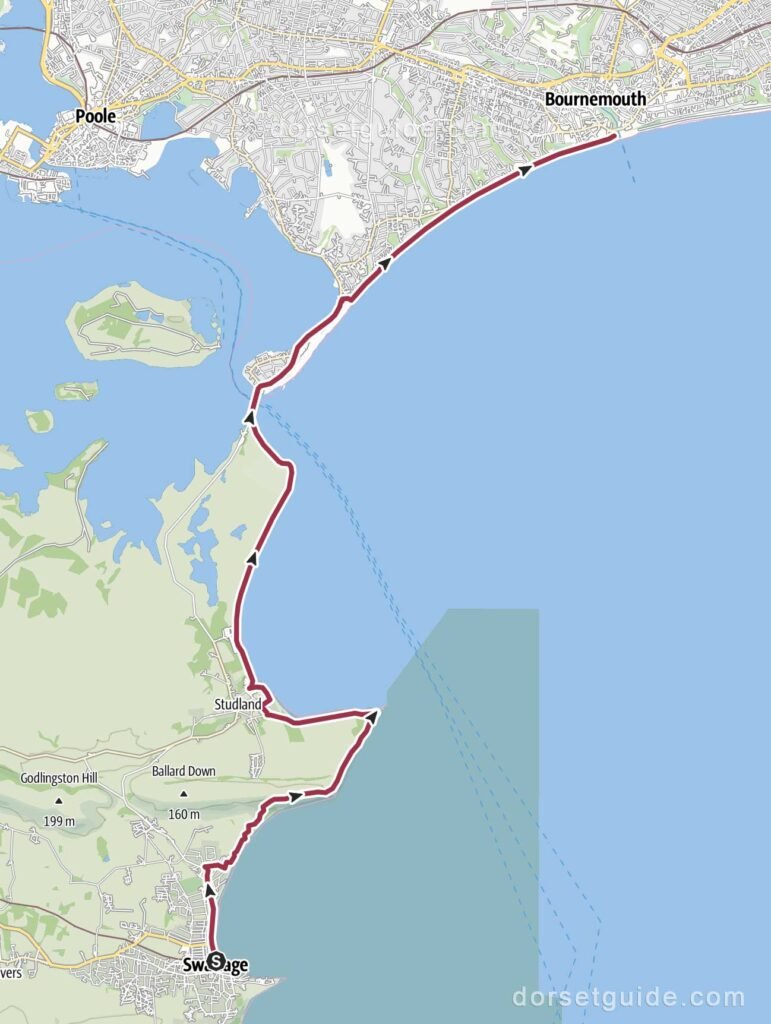
Distance: Approximately 11.7 miles (18.9 km)
Walking time: 4 hours 50 minutes
Route: Swanage – Ballard Point – Old Harry Rocks – Studland Village (Bankes Arms Inn, St. Nicholas’ Church) – Fort Henry – Middle Beach – Knoll Beach – Studland Beach (naturist) – Shell Bay – Sandbanks Ferry – Haven Point – Sandbanks Beach – Branksome Chine Beach – Alum Chine Beach – Durley Chine Beach – Bournemouth West Beach – Bournemouth Pier
GPS Map (external link): https://www.outdooractive.com/
This long but varied coastal walk extends the route to Sandbanks Ferry all the way to Bournemouth. From Swanage, the walk crosses Ballard Down to Old Harry Rocks before continuing through Studland and along Studland Bay to Shell Bay.
After crossing the entrance to Poole Harbour on the Sandbanks Ferry, the route continues through Sandbanks before joining the promenade and seafront paths towards Bournemouth. Much of this final section is relatively level and follows the coast past a succession of beaches and chines. The walk finishes at Bournemouth Pier.
With Old Harry Rocks, Studland Bay, the Sandbanks Ferry and the beaches of Poole and Bournemouth all included, this is an excellent full-day walk for anyone wanting a longer route.
Return Options
Return by Purbeck Breezer 50 bus service from Bournemouth Pier to Swanage
Swanage to Corfe Castle Walk
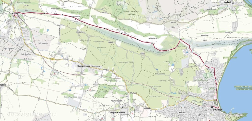
Distance: Approximately 6.1 miles (9.8 km)
Walking time: 2 hours 35 minutes
Route: Swanage – Swanage Beach – Purbeck Way – Nine Barrows Down – Corfe Castle
GPS Map (external link): https://www.outdooractive.com/
This inland walk provides a complete contrast to the coastal routes around Swanage. Leaving the town behind, the route climbs towards the Purbeck Hills before following the route of the Purbeck Way along the ridge of Nine Barrow Down towards Corfe Castle.
The elevated sections provide wide views across the Isle of Purbeck, including Poole Harbour to the north and the countryside surrounding Swanage to the south. As you approach Corfe, there are impressive views of the ruins of Corfe Castle standing above the village.
One of the attractions of this walk is the choice of return journeys. You can return to Swanage by bus, but the more memorable option is to take a heritage train on the Swanage Railway.
Return Options
- Return by Jurassic Breezer 30 or 40 bus service from Corfe Castle to Swanage
- Take the train (Swanage Historic Railway)
Swanage to Old Harry Rocks and Corfe Castle Walk
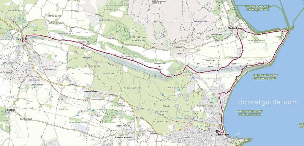
Distance: Approximately 10.7 miles (17.3 km)
Walking time: 4 hours 45 minutes
Route: Swanage – Swanage Beach – Ballard Down – Old Harry Rocks – Studland Village (Bankes Arms Inn, St. Nicholas’ Church) – Purbeck Way – Nine Barrows Down – Corfe Castle
GPS Map (external link): https://www.outdooractive.com/
This longer one-way walk combines two of the best-known landmarks around Swanage: Old Harry Rocks and Corfe Castle.
The route initially follows the coast north from Swanage before climbing onto Ballard Down and continuing to Old Harry Rocks. After visiting the chalk cliffs, the walk turns inland to Studland village before crossing the Purbeck ridge towards Nine Barrow Down.
The elevated route provides extensive views across Poole Harbour, Swanage Bay and the surrounding countryside before eventually descending towards Corfe Castle. The ruins of the castle provide a dramatic finish to the walk.
Return Options
- Return by Jurassic Breezer 30 or 40 bus service from Corfe Castle to Swanage
- Take the train (Swanage Historic Railway)
Swanage to Durlston Country Park and Dancing Ledge (Circular Walk)
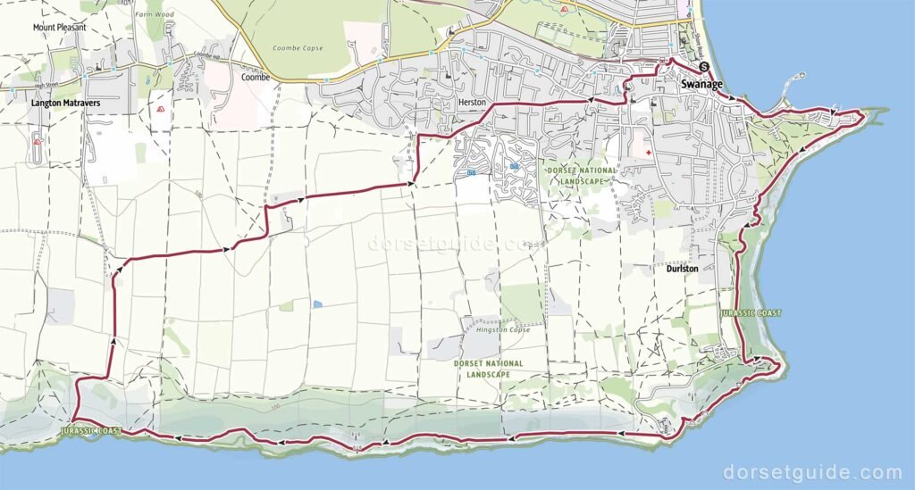
Distance: Approximately 7.7 miles (12.4 km)
Walking time: 3 hours 30 minutes
Route: Swanage – Peveril Point – Durlston Country Park – Durlston Castle – Great Globe – Anvil Point Lighthouse – Dancing Ledge – Priests Way – Mill Pond – Swanage
GPS Map (external link): https://www.outdooractive.com/
This circular walk explores the more rugged coastline west of Swanage, combining the South West Coast Path with an inland return route.
From Swanage, the route passes Peveril Point and continues through Durlston Country Park towards Anvil Point Lighthouse. From here, the coast path follows a succession of cliffs, valleys and headlands before reaching Dancing Ledge.
Dancing Ledge is a broad shelf of rock at the foot of the cliffs, created by historic quarrying. It is one of the most distinctive locations along this section of the Purbeck coast and a good place to stop before beginning the return journey.
Rather than retracing the coast path, the route heads inland and joins the Priests Way for the return towards Swanage. The walk includes several steep sections and is considerably more demanding than its distance might suggest.
Swanage to Worth Matravers Walk
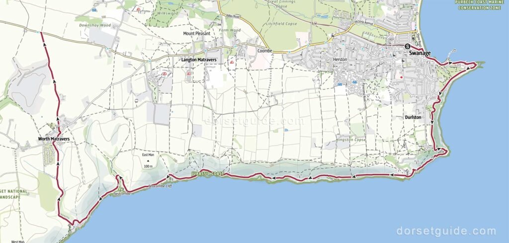
Distance: Approximately 8.6 miles (13.8 km)
Walking time: 3 hours 55 minutes
Route: Swanage (sea front) – Peveril Point – Durlston Country Park – Durlston Castle – Great Globe – Anvil Point Lighthouse – Dancing Ledge – Seacombe – Winspit Quarry – Worth Matravers – The Square & Compass
GPS Map (external link): https://www.outdooractive.com/
This one-way walk follows the South West Coast Path west from Swanage before turning inland to the attractive village of Worth Matravers.
From Swanage, the route passes Peveril Point and continues through Durlston Country Park to Anvil Point Lighthouse. Beyond the lighthouse, the coast becomes increasingly rugged, with a succession of steep-sided valleys and high limestone cliffs leading towards Dancing Ledge.
After visiting Dancing Ledge, the route continues to Winspit Quarry and then leaves the coast and climbs inland towards Worth Matravers. The village makes an excellent finishing point, with its traditional stone cottages, village pond and the Square and Compass.
Return Options
- The end of the walk as shown on the map is at the bus stop on the B3069 West Street Kingston to Swanage Road, approximately 1 mile north of the Square & Compass. This bus stop is served by the Jurassic Breezer 40 bus service from Corfe Castle to Swanage.
- If you still have the energy and not spent too much time in the Square & Compass you can depart from the pub and follow the Priests Way back to Swanage (see walk listed below). This adds approximately 3 miles (4.8 km) to your walk.
Swanage to Worth Matravers and return by Priests Way (Circular Walk)
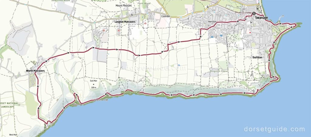
Distance: Approximately 11.5 miles (18.5 km)
Walking time: 5 hours
Route: Swanage – Peveril Point – Durlston Country Park – Durlston Castle – Great Globe – Anvil Point Lighthouse – Dancing Ledge – Seacombe – Winspit Quarry – Worth Matravers – The Square & Compass – Priests Way – Mill Pond – Swanage
GPS Map (external link): https://www.outdooractive.com/
This excellent circular walk combines some of the finest coastal scenery around Swanage with the historic quarrying landscape of the Isle of Purbeck and an inland return along the Priests Way.
Starting from Swanage seafront, the route follows the coast around Peveril Point and through Durlston Country Park, passing Durlston Castle, the Great Globe and Anvil Point Lighthouse. From here, the South West Coast Path continues west along a rugged stretch of limestone coastline to Dancing Ledge.
The walk continues past Seacombe to Winspit Quarry, where extensive former stone quarries and caves provide another reminder of Purbeck’s long quarrying history. From Winspit, the route turns inland to Worth Matravers, an attractive stone village where the historic Square & Compass pub makes a popular stopping point.
The return follows the Priests Way across the Purbeck countryside towards Swanage, eventually descending back into the town near the Mill Pond.
With dramatic cliffs, old quarries, open countryside and the village of Worth Matravers all included, this is one of the most varied longer circular walks from Swanage. There are several climbs and descents along the coastal section, so allow additional time for stops and exploring the places along the route.
Swanage to Kingston Village Walk
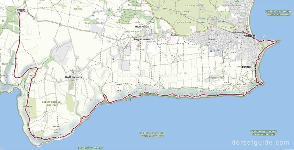
Distance: Approximately 11.3 miles (18.2 km)
Walking time: 5 hours 20 minutes
Route: Swanage (sea front) – Peveril Point – Durlston Country Park – Durlston Castle – Great Globe – Anvil Point Lighthouse – Dancing Ledge – Seacombe – Winspit Quarry – St Aldhelm’s Chapel – St Aldhelm’s Steps – Chapman’s Pool – Kingston Village – The Scott Arms Pub
GPS Map (external link): https://www.outdooractive.com/
This challenging one-way walk follows the South West Coast Path west from Swanage along one of the most dramatic sections of the Purbeck coast before finishing at Kingston.
Starting from Swanage seafront, the route passes Peveril Point and continues through Durlston Country Park, passing Durlston Castle, the Great Globe and Anvil Point Lighthouse. The coast path then continues west through a succession of steep valleys and limestone cliffs, passing Dancing Ledge, Seacombe and the former quarries at Winspit.
Beyond Winspit, the route continues towards St Aldhelm’s Head and the small Norman St Aldhelm’s Chapel. From here, the walk descends the steep St Aldhelm’s Steps towards Chapman’s Pool, a secluded bay surrounded by high cliffs.
The final section leaves the coast and climbs inland towards Kingston Village. The walk finishes at the bus stop on West Street, close to the Scott Arms pub, with views across the surrounding Purbeck countryside towards Corfe Castle.
This is one of the more demanding walks from Swanage, with numerous climbs and descents along the coast and a particularly steep section around St Aldhelm’s Head and Chapman’s Pool.
Return Options
- The end of the walk as shown on the map is at the bus stop on West Street in Kingston Village (close to the Scott Arms pub). This bus stop is served by the Jurassic Breezer 40 bus service from Corfe Castle to Swanage.