
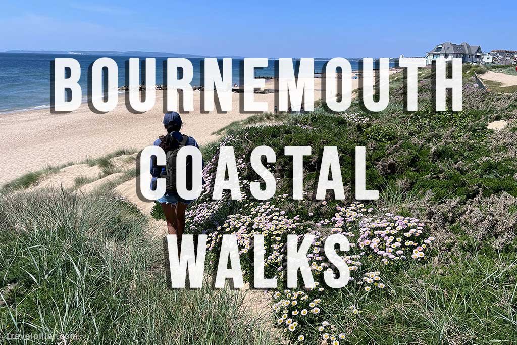
Bournemouth is one of the best places in Dorset for coastal walking. A level promenade follows the coastline for miles in both directions, making it easy to enjoy anything from a short stroll to a full-day walk. Along the way you’ll pass award-winning sandy beaches, historic piers, dramatic cliffs, nature reserves and some of the county’s most famous landmarks.
One of the great advantages of walking from Bournemouth is that you don’t always have to retrace your steps. Many routes can be combined with the Purbeck Breezer 50, the Beach Breezer 70, the Bournemouth Seafront Land Train or local ferry services, allowing you to enjoy a one-way walk before returning by public transport.
Whether you’re looking for an easy family walk to Boscombe Pier or a longer hike to Old Harry Rocks, Studland or Swanage, Bournemouth provides an excellent starting point.
Best Bournemouth Coastal Walks
1. Bournemouth Pier to Boscombe Pier
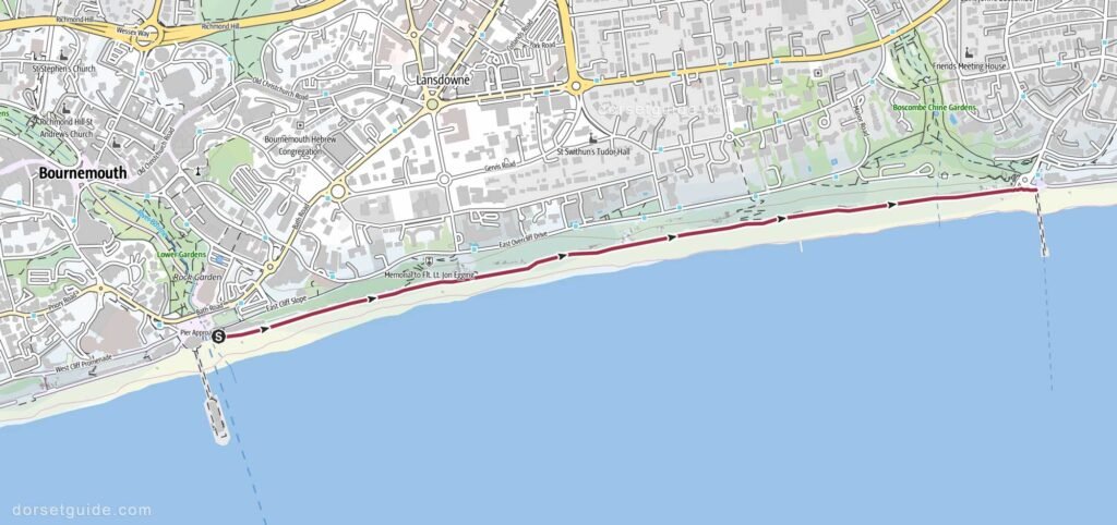
Distance: Approximately 1.5 miles (2.4 km)
Walking time: 30–35 minutes
GPS Map (external link): https://www.outdooractive.com/
This is Bournemouth’s shortest and most popular coastal walk. Following the level seafront promenade east from Bournemouth Pier, the route passes Bournemouth’s East Beach before continuing beneath the East Cliff towards Boscombe.
Boscombe Pier marks the end of the walk and offers excellent views back towards Bournemouth, together with cafés, beach facilities and one of the south coast’s best-known surfing beaches. The promenade is suitable for wheelchairs, pushchairs and cyclists, making it an excellent choice for families.
Return Options
- Walk back along the same promenade.
- Return via Boscombe Chine Gardens and East Overcliff Drive for elevated views across Poole Bay.
- Catch the Bournemouth Seafront Land Train (seasonal) back to Bournemouth Pier.
- Return on the Beach Breezer 70 bus (seasonal bus) Bus stop at roundabout by the pier.
2. Bournemouth Pier to Sandbanks Ferry
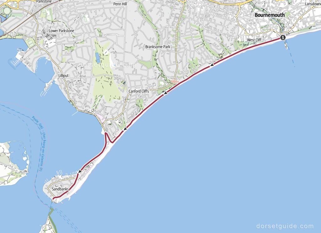
Distance: Approximately 4.3 miles (6.9 km)
Walking time: Around 1 hour 40 minutes
GPS Map (external link): https://www.outdooractive.com/
Walking west from Bournemouth Pier takes you along one of Dorset’s finest stretches of coastline. The route follows the level promenade through Durley Chine, Middle Chine, Alum Chine, Branksome Dene, Shore Road Beach and Sandbanks Beach before reaching the Sandbanks Ferry.
Although the walk remains close to the beach throughout, each section has its own character. As you leave Bournemouth behind the beaches generally become quieter, while the views across Poole Bay towards Old Harry Rocks and the Isle of Purbeck become increasingly impressive.
The Sandbanks Ferry marks the entrance to Poole Harbour and provides an enjoyable place to watch yachts, paddleboarders and other boats navigating the harbour entrance.
Return Options
- Walk back to Bournemouth along the same route.
- Return on the Purbeck Breezer 50, one of Dorset’s most scenic open-top bus routes during the summer season.
3. Bournemouth Pier to Studland Village (Optional Old Harry Rocks)
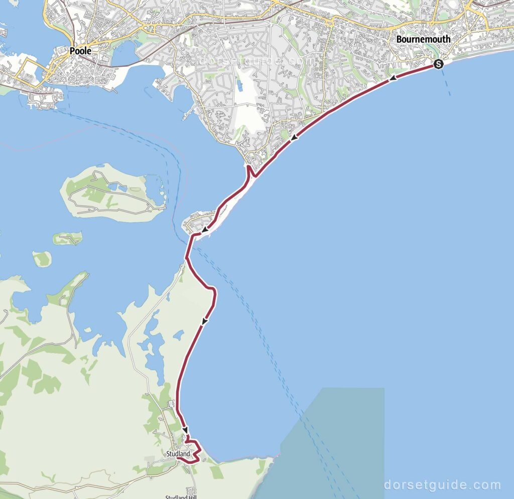
Distance: Approximately 8 miles (13 km)
Walking time: Around 3 hours 15 minutes (allow an extra hour if visiting Old Harry Rocks)
GPS Map (external link): https://www.outdooractive.com/
For many walkers, this is one of the finest coastal walks in Dorset. The route follows the promenade west from Bournemouth Pier to the Sandbanks Ferry, where a short ferry crossing takes you across the entrance to Poole Harbour. From Shell Bay, continue along the beach or coastal footpaths towards Studland Village. This walk takes you past the Bankes Arms Pub where you can stop for refreshments.
If you have time, continue to Old Harry Rocks, one of Dorset’s most famous natural landmarks. The chalk stacks mark the eastern end of the Jurassic Coast and offer spectacular views across Poole Bay towards Bournemouth and the Isle of Wight.
The additional walk to Old Harry Rocks is approximately 3.5km (2.1 miles) round trip from Studland Village. The path is clearly marked and easy to follow. Allow 1 hour plus time for taking photos.
Return Options
- Return to Bournemouth on the Purbeck Breezer 50 from Studland Village.
4. Bournemouth Pier to Swanage
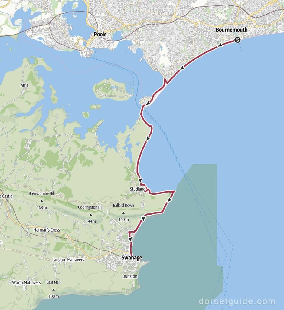
Distance: Approximately 12.2 miles (19.7 km)
Walking time: Around 5 hours 30 minutes
GPS Map (external link): https://www.outdooractive.com/
This is one of the most rewarding full-day coastal walks in Dorset. Beginning at Bournemouth Pier, the route follows the promenade to Sandbanks Ferry, crosses to Shell Bay, then continues through Studland before passing Old Harry Rocks and climbing onto Ballard Down. From here you’ll enjoy some of the finest views on the Jurassic Coast before descending into the traditional seaside town of Swanage.
Although longer than the other walks featured here, the route combines sandy beaches, dramatic chalk cliffs, rolling countryside and panoramic coastal scenery, making it a memorable day out for experienced walkers.
Return Options
- Return to Bournemouth on the Purbeck Breezer 50 from Swanage Bus Station.
5. Bournemouth Pier to Southbourne & Hengistbury Head
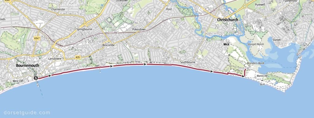
Distance: Approximately 5 miles (8 km)
Walking time: Around 1 hour 50 minutes
GPS Map (external link): https://www.outdooractive.com/
Heading east from Bournemouth Pier, this enjoyable walk follows the seafront promenade through Boscombe and Southbourne before reaching the nature reserve at Hengistbury Head.
As you leave Bournemouth behind, the beaches become quieter and the scenery increasingly natural. Hengistbury Head offers magnificent views across Christchurch Harbour, Mudeford Sandbank, the Isle of Wight and back towards Bournemouth Bay. It’s an excellent place to stop for refreshments or simply enjoy the spectacular coastal scenery.
Return Options
- Return to Bournemouth on the Beach Breezer 70 (seasonal) which departs from outside the Hiker Cafe (Google map)
- Continue to Mudeford Sandbank on the seasonal Land Train, then follow one of the return options described below in the Bournemouth Pier to Mudeford Sandbank Wak. The Hengistbury Head Land Train departs from the Hiker Cafe (Google map) more details see https://www.visithengistburyhead.co.uk/
6. Bournemouth Pier to Hengisbury Head & Tuckton Bridge
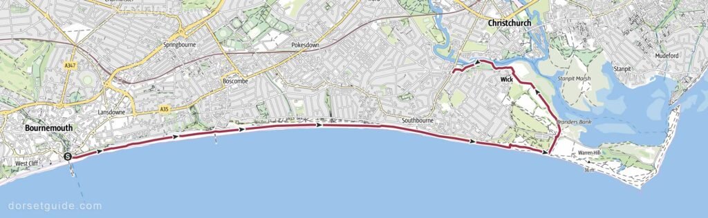
Distance: Approximately 6.5 miles (10.5 km)
Walking time: Around 2 hours 30 minutes
GPS Map (external link): https://www.outdooractive.com/
This walk follows the same route as far as Hengistbury Head Hiker Cafe (Google map) before connecting with the Stour Valley Way which follows the path alongside Christchurch Harbour to Tuckton Bridge, enjoying excellent views across the harbour and its many sailing boats, paddleboarders and wildlife.
The combination of sandy beaches, dramatic headland and peaceful riverside scenery makes this one of Bournemouth’s most varied coastal walks.
Return Options
- Return to Bournemouth on the Beach Breezer 70 (seasonal) from Tuckton Bridge. (Google map bus stop) Other buses runs throughout the year.
7. Bournemouth Pier to Mudeford Sandbank
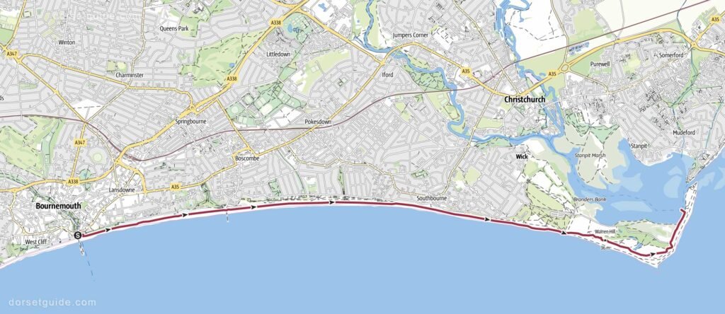
Distance: Approximately 6.3 miles (10.2 km)
Walking time: Around 2 hours 30 minutes
GPS Map (external link): https://www.outdooractive.com/
For many visitors, this is one of the finest coastal walks in the Bournemouth area. Beginning at Bournemouth Pier, the route follows the promenade through Boscombe and Southbourne before climbing onto Hengistbury Head. After enjoying the spectacular views across Christchurch Harbour and the Isle of Wight, the path descends to Mudeford Sandbank, a narrow spit famous for its colourful beach huts and beautiful sandy beach.
The walk combines some of Dorset’s best coastal scenery with panoramic viewpoints, nature reserves and one of the most picturesque harbour settings on the south coast. During the summer months, the seasonal land train across Hengistbury Head provides an alternative to walking the final section if preferred.
Return Options
Option 1 – Mudeford Ferry
Take the Mudeford Ferry across Christchurch Harbour to Mudeford Quay, then walk approximately five minutes to the Chichester Way bus stop (Google map) for the Beach Breezer 70 (seasonal) back to Bournemouth. Alternatively the 1C runs throughout the year.
Option 2 – Bournemouth Boating Ferry to Christchurch Quay
Take the Bournemouth Boating ferry across the harbour to Christchurch Quay. From there it’s a short walk into Christchurch town centre, where frequent bus services, including the Beach Breezer 70 and routes 1a, 1b and 1c, return to Bournemouth.
Option 3 – Bournemouth Boating Ferry to Tuckton
Take the Bournemouth Boating ferry to Tuckton Bridge, then catch the Beach Breezer 70 (seasonal) back to Bournemouth (Google map bus stop). Alternative year round buses also run.
Walking Tips
- Most walks begin along Bournemouth’s level seafront promenade, making the early sections suitable for most abilities.
- Wear comfortable walking shoes, particularly if continuing beyond Studland or Hengistbury Head, where paths become more uneven.
- Carry drinking water during warm weather, especially on the longer walks to Studland and Swanage.
- The Purbeck Breezer 50, Beach Breezer 70, seasonal Seafront Land Train and local ferry services make it easy to enjoy one-way walks without retracing your steps.
- Ferry services, bus timetables and land train operating dates vary throughout the year, so it’s worth checking before setting out.
- In summer, an early start is recommended to enjoy quieter paths, cooler temperatures and the best chance of finding a seat on return buses.